

Government Information
Reference Services
Dates listed are based on research that covered calendar years and various fiscal years. To the best of our ability, we have tried to use the calendar year. However, some sources did not always indicate if calendar year or fiscal year was being discussed. Also, during the process of defining the original logical geographic planning regions, not all boundaries were initially released. "[T]he commission identified tentative planning regions. However, it did not make the boundaries public until it was contacted by local groups in a geographic area that were interested in establishing a regional planning authority. At that point, CDC staff set up meetings with municipal officials to discuss the proposed boundaries. After reviewing the feedback, advice, and information from those in the region, the Connecticut Development Commission determined the final definition of the region and announced it publicly. After that, the towns within the defined area were responsible for the steps required to form a Regional Planning Authority."[14]
On June 6, 2022 Gov. Ned Lamont announced U.S. Census Bureau approved proposal for Connecticut’s Planning Regions to become County Equivalents.
These are the same Regional Councils of Governments from 2016. They might now also be called County Equivalents.
Federal Register (87 FR 34235) notes that "in some instances the name of the planning region differs from that of its COG".
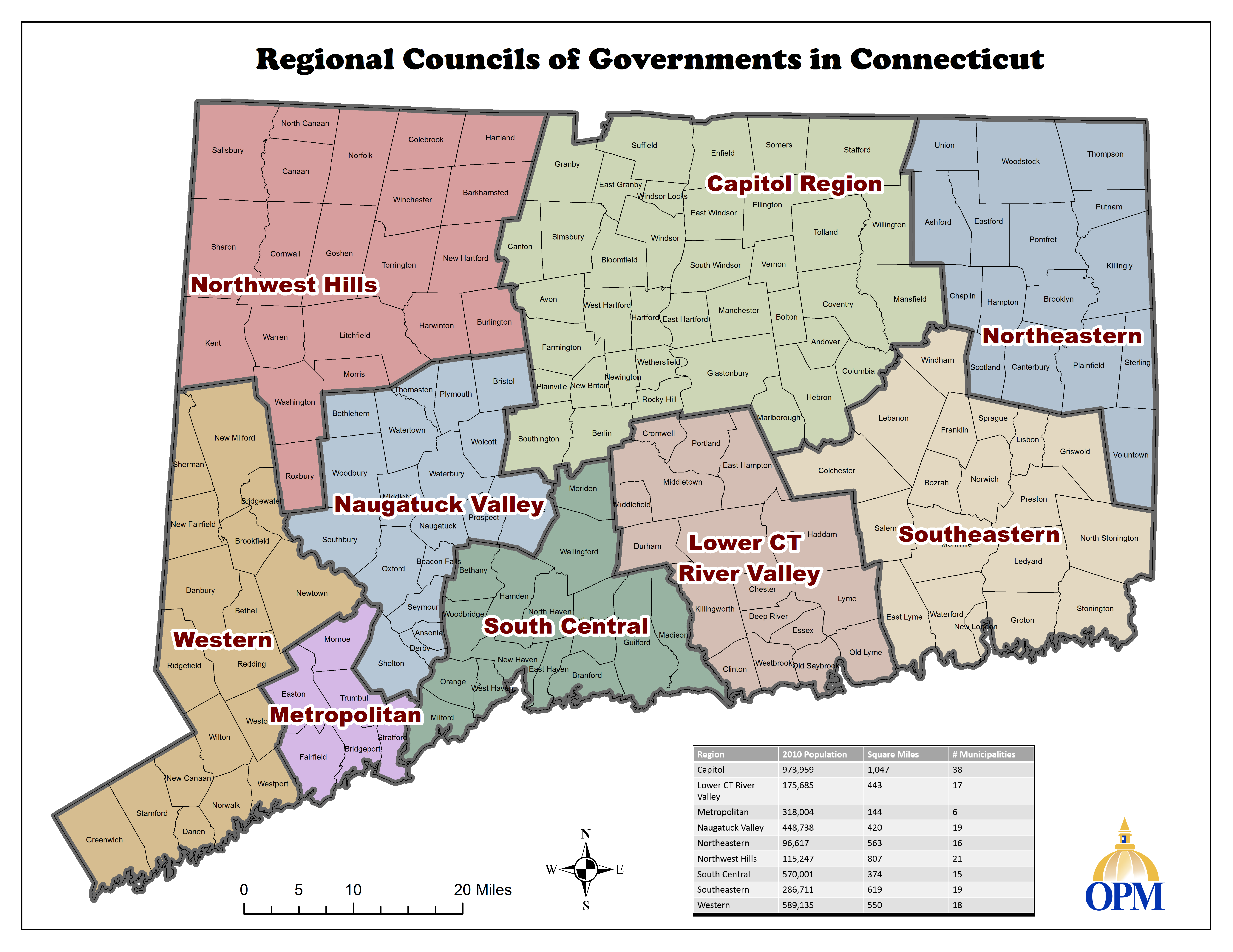
Map from the Office of Policy Management site, June 7, 2022 https://portal.ct.gov/lib/opm/igp/org/cogs/rcogs.png
| County Equivalent/Planning Region | Towns |
|---|---|
| Capitol | Andover, Avon, Berlin, Bloomfield, Bolton, Canton, Columbia, Coventry, East Granby, East Hartford, East Windsor, Ellington, Enfield, Farmington, Glastonbury, Granby, Hartford, Hebron, Manchester, Mansfield, Marlborough, New Britain, Newington, Plainville, Rocky Hill, Simsbury, Somers, South Windsor, Southington, Stafford, Suffield, Tolland, Vernon, West Hartford, Wethersfield, Willington, Windsor, Windsor Locks |
| Greater Bridgeport | Bridgeport, Easton, Fairfield, Monroe, Stratford, Trumbull |
| Lower CT River Valley | Chester, Clinton, Cromwell, Deep River, Durham, East Haddam, East Hampton, Essex, Haddam, Killingworth, Lyme, Middlefield, Middletown, Old Lyme, Old Saybrook, Portland, Westbrook |
| Naugatuck Valley | Ansonia, Beacon Falls, Bethlehem, Bristol, Cheshire, Derby, Middlebury, Naugatuck, Oxford, Plymouth, Prospect, Seymour, Shelton, Southbury, Thomaston, Waterbury, Watertown, Wolcott, Woodbury |
| Northeast CT | Ashford, Brooklyn, Canterbury, Chaplin, Eastford, Hampton, Killingly, Plainfield, Pomfret, Putnam, Scotland, Sterling, Thompson, Union, Voluntown, Woodstock |
| Northwest Hills | Barkhamsted, Burlington, Canaan, Colebrook, Cornwall, Goshen, Hartland, Harwinton, Kent, Litchfield, Morris, New Hartford, Norfolk, North Canaan, Roxbury, Salisbury, Sharon, Torrington, Warren, Washington, Winchester |
| South Central |
Bethany, Branford, East Haven, Guilford, Hamden, Madison, Meriden, Milford, New Haven, North Branford, North Haven, Orange, Wallingford, West Haven, Woodbridge |
| Southeastern CT | Bozrah, Colchester, East Lyme, Franklin, Griswold, Groton, Lebanon, Ledyard, Lisbon, Montville, New London, North Stonington, Norwich, Preston, Salem, Sprague, Stonington, Waterford, Windham |
| Western CT |
Bethel, Bridgewater, Brookfield, Danbury, Darien, Greenwich, New Canaan, New Fairfield, New Milford, Newtown, Norwalk, Redding, Ridgefield, Sherman, Stamford, Weston, Westport, Wilton |
Federal Register (87 FR 34235) notes that "in some instances the name of the planning region differs from that of its COG".
Map harvested from: [2]

The following list is of the towns within a geographic planning region according to the map above. It does not include information on voluntary municipal membership in a regional planning organization.
| Regions | Towns |
|---|---|
| Capitol Region | Andover, Avon, Berlin, Bloomfield, Bolton, Canton, Columbia, Coventry, East Granby, East Hartford, East Windsor, Ellington, Enfield, Farmington, Glastonbury, Granby, Hartford, Hebron, Manchester, Mansfield, Marlborough, New Britain, Newington, Plainville, Rocky Hill, Simsbury, Somers, South Windsor, Southington, Stafford, Suffield, Tolland, Vernon, West Hartford, Wethersfield, Willington, Windsor, Windsor Locks |
|
Greater Bridgeport (also called Metro or Metropolitan) |
Bridgeport, Easton, Fairfield, Monroe, Stratford, Trumbull |
| Lower CT River Valley | Chester, Clinton, Cromwell, Deep River, Durham, East Haddam, East Hampton, Essex, Haddam, Killingworth, Lyme, Middlefield, Middletown, Old Lyme, Old Saybrook, Portland, Westbrook |
| Naugatuck Valley | Ansonia, Beacon Falls, Bethlehem, Bristol, Cheshire, Derby, Middlebury, Naugatuck, Oxford, Plymouth, Prospect, Seymour, Shelton, Southbury, Thomaston, Waterbury, Watertown, Wolcott, Woodbury |
| Northeastern CT | Ashford, Brooklyn, Canterbury, Chaplin, Eastford, Hampton, Killingly, Plainfield, Pomfret, Putnam, Scotland, Sterling, Thompson, Union, Voluntown, Woodstock |
| Northwest Hills | Barkhamsted, Burlington, Canaan, Colebrook, Cornwall, Goshen, Hartland, Harwinton, Kent, Litchfield, Morris, New Hartford, Norfolk, North Canaan, Roxbury, Salisbury, Sharon, Torrington, Warren, Washington, Winchester |
| South Central | Bethany, Branford, East Haven, Guilford, Hamden, Madison, Meriden, Milford, New Haven, North Branford, North Haven, Orange, Wallingford, West Haven, Woodbridge |
| Southeastern | Bozrah, Colchester, East Lyme, Franklin, Griswold, Groton, Lebanon, Ledyard, Lisbon, Montville, New London, North Stonington, Norwich, Preston, Salem, Sprague, Stonington, Waterford, Windham |
| Western CT | Bethel, Bridgewater, Brookfield, Danbury, Darien, Greenwich, New Canaan, New Fairfield, New Milford, Newtown, Norwalk, Redding, Ridgefield, Sherman, Stamford, Weston, Westport, Wilton |
Map harvested from:[20]

The following list is of the towns within a geographic planning region according to the map above. It does not include information on voluntary municipal membership in a regional planning organization.
| Geographic Planning Region | Towns |
|---|---|
| Capitol | Andover, Avon, Bloomfield, Bolton, Canton, East Granby, East Hartford, East Windsor, Ellington, Enfield, Farmington, Glastonbury, Granby, Hartford, Hebron, Manchester, Marlborough, Newington, Rocky Hill, Simsbury, Somers, South Windsor, Suffield, Tolland, Vernon, West Hartford, Wethersfield, Windsor, Windsor Locks |
| Central CT | Berlin, Bristol, Burlington, New Britain, Plainville, Plymouth, Southington |
| Central Naugatuck Valley | Beacon Falls, Bethlehem, Cheshire, Middlebury, Naugatuck, Oxford, Prospect, Southbury, Thomaston, Waterbury, Watertown, Wolcott, Woodbury |
| Greater Bridgeport (also Metropolitan) | Bridgeport, Easton, Fairfield, Monroe, Stratford, Trumbull |
| Housatonic Valley | Bethel, Bridgewater, Brookfield, Danbury, New Fairfield, New Milford, Newtown, Redding, Ridgefield, Sherman |
| Lower Connecticut River Valley | Chester, Clinton, Cromwell, Deep River, Durham, East Haddam, East Hampton, Essex, Haddam, Killingworth, Lyme, Middlefield, Middletown, Old Lyme, Old Saybrook, Portland, Westbrook |
| Northeastern CT | Ashford, Brooklyn, Canterbury, Eastford, Killingly, Plainfield, Pomfret, Putnam, Sterling, Thompson, Union, Woodstock |
| Northwest Hills | Barkhamsted, Canaan, Colebrook, Cornwall, Goshen, Hartland, Harwinton, Kent, Litchfield, Morris, New Hartford, Norfolk, North Canaan, Roxbury, Salisbury, Sharon, Torrington, Warren, Washington, Winchester |
| South Central Connecticut | Bethany, Branford, East Haven, Guilford, Hamden, Madison, Meriden, Milford, New Haven, North Branford, North Haven, Orange, Wallingford, West Haven, Woodbridge |
| South Western | Darien, Greenwich, New Canaan, Norwalk, Stamford, Weston, Westport, Wilton |
| Southeastern CT | Bozrah, Colchester, East Lyme, Franklin, Griswold, Groton, Ledyard, Lisbon, Montville, New London, North Stonington, Norwich, Preston, Salem, Sprague, Stonington, Voluntown, Waterford |
| Valley | Ansonia, Derby, Seymour, Shelton |
| Windham Region | Chaplin, Columbia, Coventry, Hampton, Lebanon, Mansfield, Scotland, Willington, Windham |
| Undefined - not in a region | Stafford |
2012 Map harvested from: Connecticut Regional Planning Organizations. RiverCOG.[10]

The following list is of the towns within a geographic planning region according to the map above - with two exceptions. Union is within the defined Northeastern Connecticut Planning Region (as reflected in the 2007 map). Ashford works with the Northeastern RPO, while waiting for regions to be redefined.
The table below does not include information on voluntary municipal membership in a regional planning organization.
| Geographic Planning Region | Towns |
|---|---|
| Capitol | Andover, Avon, Bloomfield, Bolton, Canton, East Granby, East Hartford, East Windsor, Ellington, Enfield, Farmington, Glastonbury, Granby, Hartford, Hebron, Manchester, Marlborough, Newington, Rocky Hill, Simsbury, Somers, South Windsor, Suffield, Tolland, Vernon, West Hartford, Wethersfield, Windsor, Windsor Locks |
| Central CT | Berlin, Bristol, Burlington, New Britain, Plainville, Plymouth, Southington |
| Central Naugatuck Valley | Beacon Falls, Bethlehem, Cheshire, Middlebury, Naugatuck, Oxford, Prospect, Southbury, Thomaston, Waterbury, Watertown, Wolcott, Woodbury |
| Greater Bridgeport (also called Metro) | Bridgeport, Easton, Fairfield, Monroe, Stratford, Trumbull |
| Housatonic Valley | Bethel, Bridgewater, Brookfield, Danbury, New Fairfield, New Milford, Newtown, Redding, Ridgefield, Sherman |
| Litchfield Hills | Barkhamsted, Colebrook, Goshen, Hartland, Harwinton, Litchfield, Morris, New Hartford, Norfolk, Torrington, Winchester |
| Lower Connecticut River Valley | Chester, Clinton, Cromwell, Deep River, Durham, East Haddam, East Hampton, Essex, Haddam, Killingworth, Lyme, Middlefield, Middletown, Old Lyme, Old Saybrook, Portland, Westbrook |
| Northeastern CT | Ashford, Brooklyn, Canterbury, Eastford, Killingly, Plainfield, Pomfret, Putnam, Sterling, Thompson, Union, Woodstock |
| Northwestern CT | Canaan, Cornwall, Kent, North Canaan, Roxbury, Salisbury, Sharon, Warren, Washington |
| South Central CT | Bethany, Branford, East Haven, Guilford, Hamden, Madison, Meriden, Milford, New Haven, North Branford, North Haven, Orange, Wallingford, West Haven, Woodbridge |
| South Western | Darien, Greenwich, New Canaan, Norwalk, Stamford, Weston, Westport, Wilton |
| Southeastern CT | Bozrah, Colchester, East Lyme, Franklin, Griswold, Groton, Ledyard, Lisbon, Montville, New London, North Stonington, Norwich, Preston, Salem, Sprague, Stonington, Voluntown, Waterford |
| Valley | Ansonia, Derby, Seymour, Shelton |
| Windham Region | Chaplin, Columbia, Coventry, Hampton, Lebanon, Mansfield, Scotland, Willington, Windham |
| Undefined - not in a region | Stafford. (While not reflected on this map, Union is in Northeastern region) |
Map harvested from:[3]

The following list is of the towns within a geographic planning region according to the map above. It does not include information on voluntary municipal membership in a regional planning organization.
| Geographic Planning Region | Towns |
|---|---|
| Capitol | Andover, Avon, Bloomfield, Bolton, Canton, East Granby, East Hartford, East Windsor, Ellington, Enfield, Farmington, Glastonbury, Granby, Hartford, Hebron, Manchester, Marlborough, Newington, Rocky Hill, Simsbury, Somers, South Windsor, Suffield, Tolland, Vernon, West Hartford, Wethersfield, Windsor, Windsor Locks |
| Central CT | Berlin, Bristol, Burlington, New Britain, Plainville, Plymouth, Southington |
| Central Naugatuck Valley | Beacon Falls, Bethlehem, Cheshire, Middlebury, Naugatuck, Oxford, Prospect, Southbury, Thomaston, Waterbury, Watertown, Wolcott, Woodbury |
| Connecticut River Estuary | Chester, Clinton, Deep River, Essex, Killingworth, Lyme, Old Lyme, Old Saybrook, Westbrook |
| Greater Bridgeport (also called Metro) | Bridgeport, Easton, Fairfield, Monroe, Stratford, Trumbull |
| Housatonic Valley | Bethel, Bridgewater, Brookfield, Danbury, New Fairfield, New Milford, Newtown, Redding, Ridgefield, Sherman |
| Litchfield Hills | Barkhamsted, Colebrook, Goshen, Hartland, Harwinton, Litchfield, Morris, New Hartford, Norfolk, Torrington, Winchester |
| Midstate | Cromwell, Durham, East Haddam, East Hampton, Haddam, Middlefield, Middletown, Portland |
| Northeastern CT |
Ashford*, Brooklyn, Canterbury, Eastford, Killingly, Plainfield, Pomfret, Putnam, Sterling, Thompson, Union, Woodstock *While assigned to the Windham Region, Ashford works with the Northeastern RPO. |
| Northwestern CT | Canaan, Cornwall, Kent, North Canaan, Roxbury, Salisbury, Sharon, Warren, Washington |
| South Central CT | Bethany, Branford, East Haven, Guilford, Hamden, Madison, Meriden, Milford, New Haven, North Branford, North Haven, Orange, Wallingford, West Haven, Woodbridge |
| South Western | Darien, Greenwich, New Canaan, Norwalk, Stamford, Weston, Westport, Wilton |
| Southeastern CT | Bozrah, Colchester, East Lyme, Franklin, Griswold, Groton, Ledyard, Lisbon, Montville, New London, North Stonington, Norwich, Preston, Salem, Sprague, Stonington, Voluntown, Waterford |
| Valley | Ansonia, Derby, Seymour, Shelton |
| Windham Region | Ashford, Chaplin, Columbia, Coventry, Hampton, Lebanon, Mansfield, Scotland, Willington, Windham |
| Undefined - not in a region | Stafford |
Map harvested from:[4]

The following list is of the towns within a geographic planning region according to the map above. It does not include information on voluntary municipal membership in a regional planning organization.
| Geographic Planning Region | Towns |
|---|---|
| Capitol | Andover, Avon, Bloomfield, Bolton, Canton, East Granby, East Hartford, East Windsor, Ellington, Farmington, Glastonbury, Granby, Hartford, Hebron, Manchester, Marlborough, Newington, Rocky Hill, Simsbury, South Windsor, Tolland, Vernon, West Hartford, Wethersfield, Windsor, Windsor Locks |
| Central CT | Berlin, Bristol, Burlington, New Britain, Plainville, Plymouth, Southington |
| Central Naugatuck Valley | Beacon Falls, Bethlehem, Cheshire, Middlebury, Naugatuck, Oxford, Prospect, Southbury, Thomaston, Waterbury, Watertown, Wolcott, Woodbury |
| Connecticut River Estuary | Chester, Clinton, Deep River, Essex, Killingworth, Lyme, Old Lyme, Old Saybrook, Westbrook |
| Greater Bridgeport (also called Metro) | Bridgeport, Easton, Fairfield, Monroe, Stratford, Trumbull |
| Housatonic Valley | Bethel, Bridgewater, Brookfield, Danbury, New Fairfield, New Milford, Newtown, Redding, Ridgefield, Sherman |
| Litchfield Hills | Barkhamsted, Colebrook, Goshen, Hartland, Harwinton, Litchfield, Morris, New Hartford, Norfolk, Torrington, Winchester |
| Midstate | Cromwell, Durham, East Haddam, East Hampton, Haddam, Middlefield, Middletown, Portland |
| Northeastern CT |
Ashford*, Brooklyn, Canterbury, Eastford, Killingly, Plainfield, Pomfret, Putnam, Sterling, Thompson, Union, Woodstock *While assigned to the Windham Region, Ashford works with the Northeastern RPO. |
| Northwestern CT | Canaan, Cornwall, Kent, North Canaan, Roxbury, Salisbury, Sharon, Warren, Washington |
| South Central CT | Bethany, Branford, East Haven, Guilford, Hamden, Madison, Meriden, Milford, New Haven, North Branford, North Haven, Orange, Wallingford, West Haven, Woodbridge |
| South Western | Darien, Greenwich, New Canaan, Norwalk, Stamford, Weston, Westport, Wilton |
| Southeastern CT | Bozrah, Colchester, East Lyme, Franklin, Griswold, Groton, Ledyard, Lisbon, Montville, New London, North Stonington, Norwich, Preston, Salem, Sprague, Stonington, Voluntown, Waterford |
| Valley | Ansonia, Derby, Seymour, Shelton |
| Windham Region | Ashford, Chaplin, Columbia, Coventry, Hampton, Lebanon, Mansfield, Scotland, Willington, Windham |
| Undefined - not in a region | Stafford |
Map harvested from:[5]

The following list is of the towns within a geographic planning region according to the map above. It does not include information on voluntary municipal membership in a regional planning organization.
| Geographic Planning Region | Towns |
|---|---|
| Capitol | Andover, Avon, Bloomfield, Bolton, Canton, East Granby, East Hartford, East Windsor, Ellington, Enfield, Farmington, Glastonbury, Granby, Hartford, Hebron, Manchester, Marlborough, Newington, Rocky Hill, Simsbury, Somers, South Windsor, Suffield, Tolland, Vernon, West Hartford, Wethersfield, Windsor, Windsor Locks |
| Central CT | Berlin, Bristol, Burlington, New Britain, Plainville, Plymouth, Southington |
| Central Naugatuck Valley | Beacon Falls, Bethlehem, Cheshire, Middlebury, Naugatuck, Oxford, Prospect, Southbury, Thomaston, Waterbury, Watertown, Wolcott, Woodbury |
| Connecticut River Estuary | Chester, Clinton, Deep River, Essex, Killingworth, Lyme, Old Lyme, Old Saybrook, Westbrook |
| Greater Bridgeport (also called Metro) | Bridgeport, Easton, Fairfield, Monroe, Stratford, Trumbull |
| Housatonic Valley | Bethel, Bridgewater, Brookfield, Danbury, New Fairfield, New Milford, Newtown, Redding, Ridgefield, Sherman |
| Litchfield Hills | Barkhamsted, Colebrook, Goshen, Hartland, Harwinton, Litchfield, Morris, New Hartford, Norfolk, Torrington, Winchester |
| Midstate | Cromwell, Durham,East Haddam, East Hampton, Haddam, Middlefield, Middletown, Portland |
| Northeastern CT | Brooklyn, Canterbury, Eastford, Killingly, Plainfield, Pomfret, Putnam, Sterling, Thompson, Woodstock |
| Northwestern CT | Canaan, Cornwall, Kent, North Canaan, Roxbury, Salisbury, Sharon, Warren, Washington |
| South Central CT | Bethany, Branford, East Haven, Guilford, Hamden, Madison, Meriden, Milford, New Haven, North Branford, North Haven, Orange, Wallingford, West Haven, Woodbridge |
| South Western | Darien, Greenwich, New Canaan, Norwalk, Stamford, Weston, Westport, Wilton |
| Southeastern CT | Bozrah, Colchester, East Lyme, Franklin, Griswold, Groton, Ledyard, Lisbon, Montville, New London, North Stonington, Norwich, Preston, Salem, Sprague, Stonington, Voluntown, Waterford |
| Valley | Ansonia, Derby, Seymour, Shelton |
| Windham Region | Ashford, Chaplin, Columbia, Coventry, Hampton, Lebanon, Mansfield, Scotland, Willington, Windham |
| Undefined - not in a region | Stafford, Union |
Map harvested from:[6]

The following list is of the towns within a geographic planning region according to the map above. It does not include information on voluntary municipal membership in a regional planning organization.
| Geographic Planning Region | Towns |
|---|---|
| Capitol | Andover, Avon, Bloomfield, Bolton, Canton, East Granby, East Hartford, East Windsor, Ellington, Enfield, Farmington, Glastonbury, Granby, Hartford, Hebron, Manchester, Marlborough, Newington, Rocky Hill, Simsbury, Somers, South Windsor, Suffield, Tolland, Vernon, West Hartford, Wethersfield, Windsor, Windsor Locks |
| Central CT | Berlin, Bristol, Burlington, New Britain, Plainville, Plymouth, Southington |
| Central Naugatuck Valley | Beacon Falls, Bethlehem, Cheshire, Middlebury, Naugatuck, Oxford, Prospect, Southbury, Thomaston, Waterbury, Watertown, Wolcott, Woodbury |
| Connecticut River Estuary | Chester, Clinton, Deep River, Essex, Killingworth, Lyme, Old Lyme, Old Saybrook, Westbrook |
| Greater Bridgeport (also called Metro) | Bridgeport, Easton, Fairfield, Monroe, Stratford, Trumbull |
| Housatonic Valley | Bethel, Bridgewater, Brookfield, Danbury, New Fairfield, New Milford, Newtown, Redding, Ridgefield, Sherman |
| Litchfield Hills | Barkhamsted, Colebrook, Goshen, Hartland, Harwinton, Litchfield, Morris, New Hartford, Norfolk, Torrington, Winchester |
| Midstate | Cromwell, Durham,East Haddam, East Hampton, Haddam, Middlefield, Middletown, Portland |
| Northeastern CT | Brooklyn, Canterbury, Eastford, Killingly, Plainfield, Pomfret, Putnam, Sterling, Thompson, Woodstock |
| Northwestern CT | Canaan, Cornwall, Kent, North Canaan, Roxbury, Salisbury, Sharon, Warren, Washington |
| South Central CT | Bethany, Branford, East Haven, Guilford, Hamden, Madison, Meriden, Milford, New Haven, North Branford, North Haven, Orange, Wallingford, West Haven, Woodbridge |
| South Western | Darien, Greenwich, New Canaan, Norwalk, Stamford, Weston, Westport, Wilton |
| Southeastern CT | Bozrah, Colchester, East Lyme, Franklin, Griswold, Groton, Ledyard, Lisbon, Montville, New London, North Stonington, Norwich, Preston, Salem, Sprague, Stonington, Voluntown, Waterford |
| Valley | Ansonia, Derby, Seymour, Shelton |
| Windham Region | Ashford, Chaplin, Columbia, Coventry, Hampton, Lebanon, Mansfield, Scotland, Willington, Windham |
| Undefined - not in a region | Stafford, Union |
Map harvested from:[1]

The following list is of the towns within a geographic planning region according to the map above. It does not include information on voluntary municipal membership in a regional planning organization.
| Geographic Planning Region | Towns |
|---|---|
| Capitol | Andover, Avon, Bloomfield, Bolton, Canton, East Granby, East Hartford, East Windsor, Ellington, Enfield, Farmington, Glastonbury, Granby, Hartford, Hebron, Manchester, Marlborough, Newington, Rocky Hill, Simsbury, Somers, South Windsor, Suffield, Tolland, Vernon, West Hartford, Wethersfield, Windsor, Windsor Locks |
| Central CT | Berlin, Bristol, Burlington, New Britain, Plainville, Plymouth, Southington |
| Central Naugatuck Valley | Beacon Falls, Bethlehem, Cheshire, Middlebury, Naugatuck, Oxford, Prospect, Southbury, Thomaston, Waterbury, Watertown, Wolcott, Woodbury |
| Connecticut River Estuary | Chester, Clinton, Deep River, Essex, Killingworth, Lyme, Old Lyme, Old Saybrook, Westbrook |
| Greater Bridgeport (also called Metro) | Bridgeport, Easton, Fairfield, Monroe, Stratford, Trumbull |
| Housatonic Valley | Bethel, Bridgewater, Brookfield, Danbury, New Fairfield, New Milford, Newtown, Redding, Ridgefield, Sherman |
| Litchfield Hills | Barkhamsted, Colebrook, Goshen, Hartland, Harwinton, Litchfield, Morris, New Hartford, Norfolk, Torrington, Winchester |
| Midstate | Cromwell, Durham, East Haddam, East Hampton, Haddam, Middlefield, Middletown, Portland |
| Northeastern CT | Brooklyn, Canterbury, Eastford, Killingly, Plainfield, Pomfret, Putnam, Sterling, Thompson, Woodstock |
| Northwestern CT | Canaan, Cornwall, Kent, North Canaan, Roxbury, Salisbury, Sharon, Warren, Washington |
| South Central CT | Bethany, Branford, East Haven, Guilford, Hamden, Madison, Meriden, Milford, New Haven, North Branford, North Haven, Orange, Wallingford, West Haven, Woodbridge |
| South Western | Darien, Greenwich, New Canaan, Norwalk, Stamford, Weston, Westport, Wilton |
| Southeastern CT | Bozrah, Colchester, East Lyme, Franklin, Griswold, Groton, Ledyard, Lisbon, Montville, New London, North Stonington, Norwich, Preston, Salem, Sprague, Stonington, Voluntown, Waterford |
| Valley | Ansonia, Derby, Seymour, Shelton |
| Windham Region | Ashford, Chaplin, Columbia, Coventry, Hampton, Lebanon, Mansfield, Scotland, Willington, Windham |
| Undefined - not in a region | Stafford, Union |
Map harvested from: page 11[22]
Towns are not listed, as they were not included in the map of 15 regional planning areas. There are differences from the previous and later maps.

The following list is of the planning regions according to the map above. It does not include information on towns, as the map does not include this.
| Geographic Planning Region |
|---|
| Capitol |
| Central Conn. |
| Central Naugatuck Valley |
| Connecticut River Estuary |
| Greater Bridgeport |
| Housatonic Valley |
| Litchfield Hills |
| Midstate |
| Northeastern |
| Northwestern |
| South Central |
| South Western |
| Southeastern |
| Valley |
| Windham Region |
| Undefined - not in a region |
map harvested from [24]

The following list is of the towns within a geographic planning region according to the map above.
| Geographic Planning Region | Towns |
|---|---|
| Capitol | Andover, Avon, Bloomfield, Bolton, Canton, East Granby, East Hartford, East Windsor, Ellington, Enfield, Farmington, Glastonbury, Granby, Hartford, Hebron (not participating), Manchester, Marlborough, Newington, Rocky Hill, Simsbury, Somers, South Windsor, Suffield, Tolland, Vernon, West Hartford, Wethersfield, Windsor, Windsor Locks |
| Central CT | Berlin, Bristol, Burlington (not participating), New Britain, Plainville, Plymouth, Southington |
| Central Naugatuck Valley | Beacon Falls, Bethlehem, Cheshire, Middlebury, Naugatuck, Oxford, Prospect, Southbury, Thomaston, Waterbury, Watertown, Wolcott, Woodbury |
| Connecticut River Estuary | Chester, Clinton, Deep River, Essex, Killingworth (not participating), Lyme, Old Lyme, Old Saybrook, Westbrook (not participating) |
| Greater Bridgeport (also called Metro) | Bridgeport, Easton (not participating), Fairfield, Monroe, Stratford, Trumbull |
| Housatonic Valley | Bethel (not participating), Brookfield (not participating), Danbury, New Fairfield (not participating), Newtown (not participating), Redding, Ridgefield (not participating) |
| Litchfield Hills | Barkhamsted, Colebrook (not participating), Goshen, Harwinton, Litchfield, Morris, New Hartford, Norfolk, Torrington, Winchester |
| Midstate | Cromwell, Durham, East Haddam, East Hampton, Haddam, Middlefield, Middletown, Portland |
| Northeastern CT | Brooklyn, Canterbury, Eastford, Killingly, Plainfield, Pomfret, Putnam, Sterling, Thompson, Woodstock |
| Northwestern CT | Area defined, no organization. Canaan, Cornwall, Kent, North Canaan, Roxbury, Salisbury, Sharon, Warren, Washington |
| South Central CT | Bethany, Branford, East Haven, Guilford, Hamden, Madison, Meriden, Milford, New Haven, North Branford, North Haven, Orange, Wallingford, West Haven, Woodbridge |
| South Western | Darien, Greenwich (not participating), New Canaan (not participating), Norwalk, Stamford, Weston, Westport, Wilton (not participating) |
| Southeastern CT | Bozrah, Colchester, East Lyme (not participating), Franklin, Griswold, Groton, Ledyard, Lisbon, Montville, New London, North Stonington, Norwich, Preston, Salem, Sprague, Stonington, Voluntown (not participating), Waterford |
| Valley | Ansonia, Derby, Seymour, Shelton |
| Windham Region | Ashford, Chaplin, Columbia, Coventry, Hampton, Lebanon, Mansfield, Scotland, Willington (not participating), Windham |
| Undefined - not in a region | Bridgewater, Hartland, New Milford, Sherman, Stafford, Union |
Map harvested from Source 23 [23]:
This map is as clear as possible - the print was very small on the original document. It is not paginated.
"The boundaries of the Midstate Planning Region, originally designated as the Northern Middlesex County Region, are determined by the Planning and Budgeting Division of the Department of Finance and Control, State of Connecticut, as specified by Connecticut's regional planning enabling legislation. Factors which are considered in this determination include economic and social interrelationships, common physiographic features, similar community goals, a degree of balance and self-sufficiency, common areas of concern, etc."
"The original definition of the Midstate Planning Region included the seven towns of Cromwell, Durham, East Hampton, Haddam, Middlefield, Middletown and Portland. After intensive study and reevaluation of the factors which influenced the region's boundaries, the Connecticut Development Commission, at its meeting of June 21, 1967, redefined the region to include the Town of East Haddam."

Map harvested from:[21, p.8]
Temporary citation until coding an be fixed:
Map from: page 8 of #21 on works cited page. https://libguides.ctstatelibrary.org/regionalplanning/cited#En90com19651970
Citation from our library catalog (Primo):
Connecticut. Department of Agriculture Natural Resources, Connecticut Development Commission, and Vollmer Associates. Connecticut Comprehensive Statewide Outdoor Recreation Plan, 1965-1970. [Hartford]: State of Connecticut, Dept. of Agricultural and Natural Resources : Connecticut Development Commission : Connecticut State Highway Dept., 1966. Location: Conn Doc En90 com 1965-1970

The following list is of the towns within a geographic planning region according to the map above. It does not include information on voluntary municipal membership in a regional planning organization.
| Geographic Planning Region | Towns |
|---|---|
| Ansonia Derby | Ansonia, Derby, Seymour, Shelton |
| Capitol | Andover, Avon, Bloomfield, Bolton, Canton, East Granby, East Hartford, East Windsor, Ellington, Enfield, Farmington, Glastonbury, Granby, Hartford, Hebron, Manchester, Marlborough, Newington, Rocky Hill, Simsbury, Somers, South Windsor, Suffield, Tolland, Vernon, West Hartford, Wethersfield, Windsor, Windsor Locks |
| Central Naugatuck Valley | Beacon Falls, Bethlehem, Cheshire, Middlebury, Naugatuck, Oxford, Prospect, Southbury, Thomaston, Waterbury, Watertown, Wolcott, Woodbury |
| Connecticut River Estuary | Chester, Clinton, Deep River, East Haddam, Essex, Killingworth, Lyme, Old Lyme, Old Saybrook, Westbrook |
| Greater Bridgeport (also called Metro) | Bridgeport, Easton, Fairfield, Monroe, Stratford, Trumbull |
| Housatonic Valley | Bethel, Bridgewater, Brookfield, Danbury, New Fairfield, New Milford, Newtown, Redding, Ridgefield, Sherman |
| Midstate | Cromwell, Durham, East Hampton, Haddam, Middlefield, Middletown, Portland |
| New Britain Bristol | Berlin, Bristol, Burlington, New Britain, Plainville, Plymouth, Southington |
| Northeastern CT | Brooklyn, Canterbury, Eastford, Killingly, Plainfield, Pomfret, Putnam, Sterling, Thompson, Woodstock |
| Northwestern CT | Canaan, Cornwall, Kent, North Canaan, Roxbury, Salisbury, Sharon, Warren, Washington |
| South Central CT | Bethany, Branford, East Haven, Guilford, Hamden, Madison, Meriden, Milford, New Haven, North Branford, North Haven, Orange, Wallingford, West Haven, Woodbridge |
| South Western | Darien, Greenwich, New Canaan, Norwalk, Stamford, Weston, Westport, Wilton |
| Southeastern CT | Bozrah, East Lyme, Franklin, Griswold, Groton, Ledyard, Lisbon, Montville, New London, North Stonington, Norwich, Preston, Salem, Sprague, Stonington, Voluntown, Waterford |
| Torrington Winchester | Barkhamsted, Colebrook, Goshen, Harwinton, Litchfield, Morris, New Hartford, Norfolk, Torrington, Winchester |
| Windham Region | Ashford, Chaplin, Columbia, Coventry, Hampton, Lebanon, Mansfield, Scotland, Willington, Windham |
| Undefined - not in a region | Colchester, Hartland, Stafford, Union |
Map harvested from:[7]

The following list is of the towns within a geographic planning region according to the map above. It does not include information on voluntary municipal membership in a regional planning organization.
| Geographic Planning Region | Towns |
|---|---|
| Ansonia Derby | Ansonia, Derby, Seymour, Shelton |
| Capitol | Andover, Avon, Bloomfield, Bolton, Canton, East Granby, East Hartford, East Windsor, Ellington, Farmington, Glastonbury, Granby, Hartford, Hebron, Manchester, Marlborough, Newington, Rocky Hill, Simsbury, South Windsor, Tolland, Vernon, West Hartford, Wethersfield, Windsor, Windsor Locks |
| Central Naugatuck Valley | Beacon Falls, Bethlehem, Cheshire, Middlebury, Naugatuck, Oxford, Prospect, Southbury, Thomaston, Waterbury, Watertown, Wolcott, Woodbury |
| Connecticut River Estuary | Chester, Clinton, Deep River, East Haddam, Essex, Killingworth, Lyme, Old Lyme, Old Saybrook, Westbrook |
| Greater Bridgeport (also called Metro) | Bridgeport, Easton, Fairfield, Monroe, Stratford, Trumbull |
|
Danbury* *Became Housatonic Valley |
Bethel, Bridgewater, Brookfield, Danbury, New Fairfield, New Milford, Newtown, Redding, Ridgefield, Roxbury, Sherman, Washington |
|
Housatonic Valley* Was Danbury |
Bethel, Bridgewater, Brookfield, Danbury, New Fairfield, New Milford, Newtown, Redding, Ridgefield, Sherman |
| Midstate | Cromwell, Durham, East Hampton, Haddam, Middlefield, Middletown, Portland |
| New Britain Bristol | Berlin, Bristol, Burlington, New Britain, Plainville, Plymouth, Southington |
| Northeastern CT | Brooklyn, Canterbury, Eastford, Killingly, Plainfield, Pomfret, Putnam, Sterling, Thompson, Woodstock |
| Northwestern CT |
Canaan, Cornwall, Kent, North Canaan, Roxbury*, Salisbury, Sharon, Warren, Washington* *When Danbury was redefined as Housatonic Valley, Roxbury and Washington were not included. They became part of Northwestern. |
| South Central CT | Bethany, Branford, East Haven, Guilford, Hamden, Madison, Meriden, Milford, New Haven, North Branford, North Haven, Orange, Wallingford, West Haven, Woodbridge |
| South Western | Darien, Greenwich, New Canaan, Norwalk, Stamford, Weston, Westport, Wilton |
| Southeastern CT | Bozrah, East Lyme, Franklin, Griswold, Groton, Ledyard, Lisbon, Montville, New London, North Stonington, Norwich, Preston, Salem, Sprague, Stonington, Voluntown, Waterford |
| Torrington Winchester | Barkhamsted, Colebrook, Goshen, Harwinton, Litchfield, Morris, New Hartford, Norfolk, Torrington, Winchester |
| Windham Region | Ashford, Chaplin, Columbia, Coventry, Hampton, Lebanon, Mansfield, Scotland, Willington, Windham |
| Undefined - not in a region | Colchester, Enfield, Hartland, Somers, Stafford, Suffield, Union |