

Government Information
Reference Services
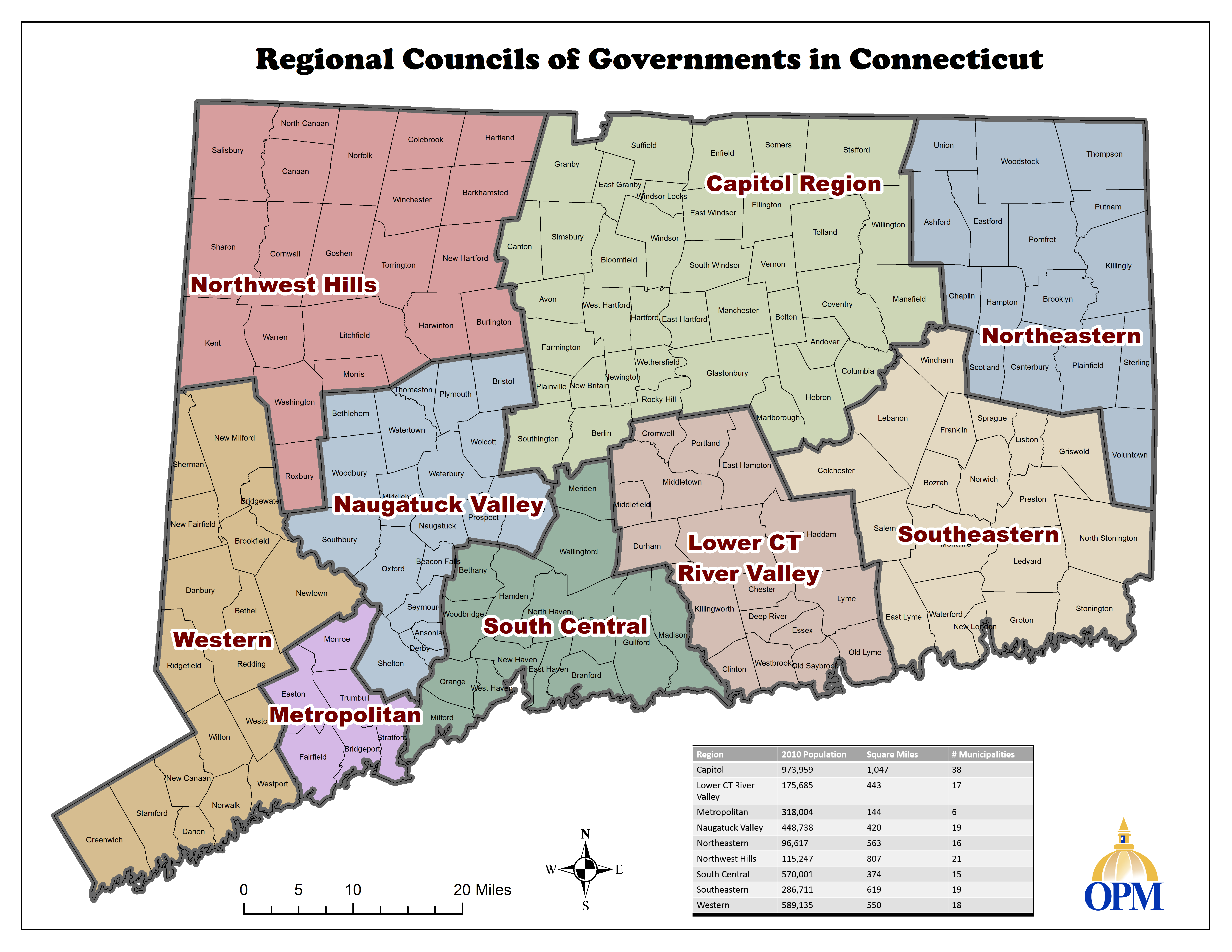
The Planning Regions are the logical geographic areas defined and named by the Office of Policy and Management (OPM), as per statutes:
As of January 1, 2015, Connecticut has nine geographic regional planning areas. Municipalities may petition OPM for a change in their geographic region, as was done during the process to reduce the 15 geographic planning regions into 9 geographic planning regions.
OPM has the authority to define or redefine the "logical regional planning areas", which were originally defined by the Connecticut Development Commission (CDC ). The goal is to group municipalities with common interest and problems based on numerous geographic, economic and social factors. Detailed studies were originally conducted with subsequent research over the years. The state-defined logical regional planning areas may include the federally-defined metropolitan planning area for transportation planning.
The table below, or the page with maps, may be used to see previous boundaries for the geographic regional planning areas. The focus is on the state-defined geographic region, not voluntary membership in planning organizations.
Current 9 Regions |
Towns |
|---|---|
| Capitol | Andover, Avon, Berlin, Bloomfield, Bolton, Canton, Columbia, Coventry, East Granby, East Hartford, East Windsor, Ellington, Enfield, Farmington, Glastonbury, Granby, Hartford, Hebron, Manchester, Mansfield, Marlborough, New Britain, Newington, Plainville, Rocky Hill, Simsbury, Somers, South Windsor, Southington, Stafford, Suffield, Tolland, Vernon, West Hartford, Wethersfield, Willington, Windsor, Windsor Locks |
| Greater Bridgeport (Metropolitan) | Bridgeport, Easton, Fairfield, Monroe, Stratford, Trumbull |
| Lower CT River Valley | Chester, Clinton, Cromwell, Deep River, Durham, East Haddam, East Hampton, Essex, Haddam, Killingworth, Lyme, Middlefield, Middletown, Old Lyme, Old Saybrook, Portland, Westbrook |
| Naugatuck Valley | Ansonia, Beacon Falls, Bethlehem, Bristol, Cheshire, Derby, Middlebury, Naugatuck, Oxford, Plymouth, Prospect, Seymour, Shelton, Southbury, Thomaston, Waterbury, Watertown, Wolcott, Woodbury |
|
Northeastern |
Ashford, Brooklyn, Canterbury, Chaplin, Eastford, Hampton, Killingly, Plainfield, Pomfret, Putnam, Scotland, Sterling, Thompson, Union, Voluntown, Woodstock |
| Northwest Hills | Barkhamsted, Burlington, Canaan, Colebrook, Cornwall, Goshen, Hartland, Harwinton, Kent, Litchfield, Morris, New Hartford, Norfolk, North Canaan, Roxbury, Salisbury, Sharon, Torrington, Warren, Washington, Winchester |
| South Central | Bethany, Branford, East Haven, Guilford, Hamden, Madison, Meriden, Milford, New Haven, North Branford, North Haven, Orange, Wallingford, West Haven, Woodbridge |
| Southeastern | Bozrah, Colchester, East Lyme, Franklin, Griswold, Groton, Lebanon, Ledyard, Lisbon, Montville, New London, North Stonington, Norwich, Preston, Salem, Sprague, Stonington, Waterford, Windham |
| Western | Bethel, Bridgewater, Brookfield, Danbury, Darien, Greenwich, New Canaan, New Fairfield, New Milford, Newtown, Norwalk, Redding, Ridgefield, Sherman, Stamford, Weston, Westport, Wilton |
These are only a few selected items. See also the page of Works Cited for this research guide.
For additional resources, please search: